

Agnes Water is an increasingly popular tourist town located on the Discovery Coast of Queensland, Australia. It is situated approximately 80 km south-east of the Bruce Highway, Queensland's major coastal route. It is accessed via the main road in called Round Hill Road. It is 90 minutes south of Gladstone, and 90 minutes north of Bundaberg on the Discovery Coast. Agnes Water is the closest access point to the Southern Great Barrier Reef.[citation needed] It is a neighboring town of the Town of
1770 History,
Agnes Water was reportedly named after a coastal schooner, the Agnes, lost at sea in 1873, most probably off the surf coast. Five years later the locality was under a pastoral lease to Daniel Clowes, who remained there until his death in 1891. The gravestones of Clowes and his wife are near the present township. There was saw milling in the locality in the 1890s and the wide beach was a popular venue, particularly as buggies could be driven on to it. It became a holiday destination, and weekend residences were built, notably on Round Hill where the Town of 1770 was officially named in 1936. Agnes Water used to be a relatively remote beach located 115 km north of Bundaberg and 60 km off the Bruce Highway. Furthermore, most of the road was into the town was only sealed in the mid 1990s. It really only began opening up in the 1990s
.
Beaches and fishing
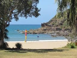
The main beach is 5.5 km long, running from Round Hill in the north down to Agnes Water. The beach is relatively straight and faces east-north-east. It is famous amongst surfers as being the most northerly beach on the east coast to regularly receive Tasman Sea swell which, when it arrives, provides some excellent surf.[citation needed] Most of the beach is backed by a low dune and natural vegetation. At the southern Agnes Water end there is an extensive foreshore reserve, including a camping reserve. The beach usually receives waves averaging about one meter, which combine with the medium sand to build a moderately steep high tide beach, with a continuous bar exposed at low tide. During and following higher swell, up to 30 rip channels are cut across the lower
section of the bar and an outer bar forms along the central and northern sections of the beach. The rip channels will persist for some weeks during lower wave conditions. As well as the surf beach, Agnes Water is intersected by rocky headlands and has a stream behind the coastline. A relatively safe beach in the southern patrolled area.
.
The main beach is 5.5 km long, running from Round Hill in the north down to Agnes Water. The beach is relatively straight and faces east-
.


